
Information
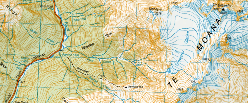
Brewster Hut Track (5.3km return) is within Mt Aspiring National Park, about 10km from Makarora on the Haast Pass – Makarora Road. Starting point is Fantail Fall car park. Brewster Hut is at 1448 m, an elevation gain of 954m (3-4 hours steep climb). The stunning Brewster Glacier (1600m) can also be accessed via a steep and sometimes slippery slope. Climb Mt Armstrong (2174m) for incredible views. However, the routes are unmarked but assisted (sometimes unreliable especially in poor weather) with rock cairns. Booking is required for the 12 – bunk hut and purchased at DoC. This track is rated as advanced and for experienced hikers. Avalanches, wet weather and fog are potential hazards.
Day Zero
In early March, the drive from Wanaka to Makarora (63 km) is quite spectacular – between Lakes Wanaka and Hawea. Beyond Makarora, the road weaves through dense rain forest along Makarora and later Haast Rivers via Haast Pass.
I know it was going to be tough as the track is straight up, to 1450m. From the topo map, the ‘path’ towards Mt Armstrong and Brewster Glacier climb even higher and steeper! I booked the hut for two nights. At DoC office, I was informed to be the only occupant (with no other bookings) – taking isolation due to covid to the extreme!
To get an early start, I stayed at Makarora at Wonderland Lodge, at the base of Mt Shrimpton. Due to covid, the restaurant and office were closed with no staff present. I had to be self sufficient. However, there is a fully equipped kitchen.
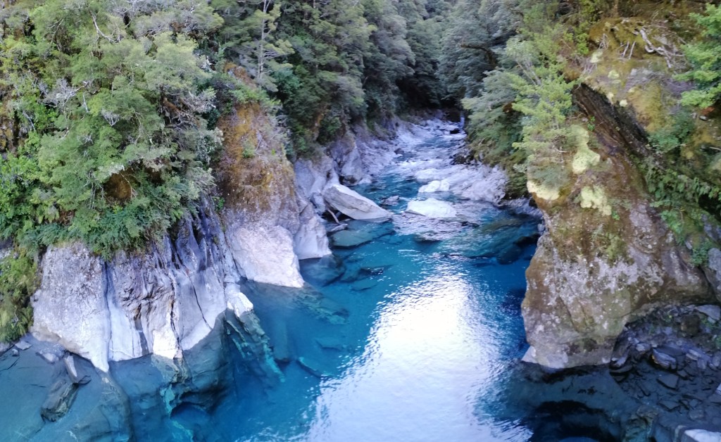
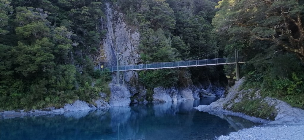
Just a short drive away is the captivating Blue Pools. Its a 3km return walk through beech and podocarp forest in Mt Aspiring National Park. On my previous visit, the water was emerald green. Standing on a swing bridge over the Blue River near the Makarora River, the pool was stunning blue. The colour of the river is determined by the volume of rock flour (fine dust created by glacial movements). Walk down to the river to get a different perspective. Beware, sand flies awaits!

The Track – Day 1
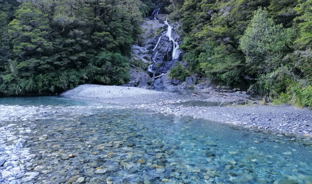
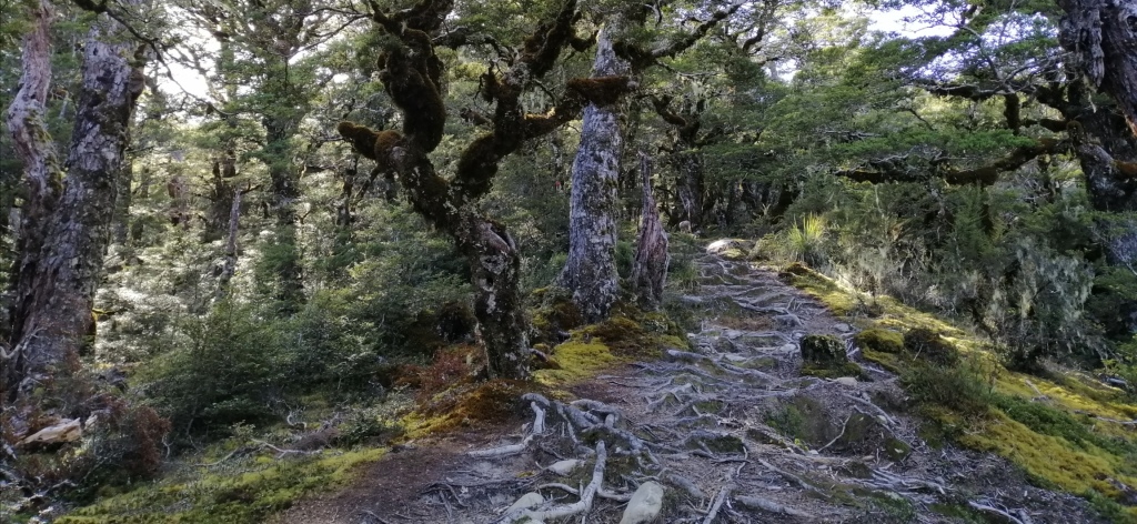
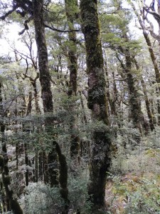
The following day, Brewster Hut Track started at Fantail Falls car park. First, a short walk to Fantail Falls across Haast River is an interesting start. Rock cairns on the shallow river added some interest at the refreshing falls. Back at the car park, at 0930, a short walk across a shallow but cold and fast flowing Haast River is the start of the Brewster Track. The water was knee deep. The crossing is only advised when shallow. A large DoC orange triangle marker indicated the start of the track. It was a heave up the steep river slope aided by tree roots and immediately into dense beech forest. From hereon, the track is steep and essentially clambering up through intertwined beech tree roots. Numerous times legs and hands were needed. The ground under the tree canopy is covered with lime green sphagnum moss and ground crown ferns. Some of the matured tree trunks and branches were covered with black fungus. The strenuous steep climb over difficult terrain was made ‘pleasant’ by the shady tree canopy.


At 1130, after climbing relentlessly, I emerged out of the bush line into the exposed tussock grasses. With no tree canopy for shade, the sun took its toll. The track is still steep and sometimes through water eroded gullies. Bare mountain peaks on the west of Haast Valley became visible. With elevation, the views of Mt Aspiring NP and Southern Alps became more panoramic. In the forested valley below, Haast highway snaked alongside Haast River towards the west coast.
With elevation gain, tussock grasses were replaced by alpine vegetation. The track is a narrow path through the tops of several narrow mountain ridges with steep drop-offs. Mts Brewster and Top Heavy loomed in the east. With slow progress, at 1230, Mt Armstrong appeared on the horizon. It was still a long way to go. However, the views at this point were already outstanding. On the exposed ridges, the sun was intense and there was hardly any wind. At the end on one ridge, there was another and another. It seemed unending.


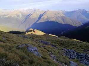
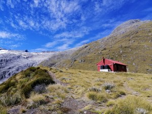
After much “grunt, gasp and pant”, I was happy to see the drop toilet against the backdrop of Mts Brewster and Armstrong. Who would have thought that the sight of a toilet would bring some respite! I finally arrived at the cardinal red Brewster Hut at 1245. The ardours climb had taken me 3.5 hrs. On the hut’s deck, the 360 degree view was stunning. At 1450m, the peaks on Aspiring Range were almost at eye-level. The hut’s location, tucked in the middle of the Southern Alps, is absolutely amazing. My original plan was to hike here in early December with some lingering snow (postponed due to covid lock – downs). Today, I just imagined it. It was a good feeling. Two hikers were about to descend. No one else.

As I gazed towards Mts Armstrong and Brewster, a tramper advised me to follow the unofficial marker, piles of rock cairns. Soon, they left. I was alone, not knowing if there would be anyone else today. After a hot soups and short rest, surprisingly, I found myself keen to continue walking uphill! So I decided to climb Mt Armstrong to gain elevation. I started to ascend at 1400. The uphill path is uneven and unstable as rock and stones move with every step. With a lot of grunt, I inched up the mountain. The sky was blue and sun was intense with no breeze. Brewster Hut was barely visible against a backdrop of rising peaks and ribbon-like Haast River.


Stunning views of Brewster Glacier and its turquoise lake appeared in the east, flanked by Mt Brewster and Top Heavy. As much as I followed the random rock cairns, I ended up scrambling up sheer cliffs of the rock face. Many times, I had no idea where I was going, but just up. Perhaps, above 1600 meters, I was lost. I looked for signs but just sharp rocks and boulders spewed all over. It had taken me about two hours to get here. I looked up and perhaps, just 30 m away seemed to be the top. Beyond that, over to the left, a little peak jutted out.
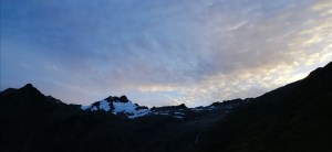
Out from nowhere, thick clouds descended from the west and covered Mt Armstrong. Visibility was limited to just a few meters. I was undecided as to ascend or descend. I waited for 20 minutes and the cloud cover did not recede. In haste, I descended straight down the mountain slope. The clouds suddenly disappeared and I caught sight of the red hut. I then realised, the effort to get up again was too much. With regret, I headed down back to the hut. I was so close to seeing what laid beyond that 30 meters. It turned out to be a brilliant day. Seven hikers at the hut today sat on the deck for dinner and enjoy the rather cloudy sunset. Surprisingly, it was still warm at dusk. A thick band of clouds blanketed Mts Brewster and Top Heavy. The night sky was brilliant as the hazy band of stars -the milky way, crossed the sky. Everyone picked a spot and watched in silence. The effect of nature’s beauty.


The Track – Day 2
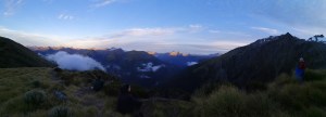
It was cold and really quiet this early morning. The sun was just emerging but hidden behind Mt Brewster. Pockets of fog filled Haast Valley. However, the Makarora – Haast road was visible. One by one, fellow hikers picked a spot at the edge of this mountain, outside the hut. No words were spoken. Each in their own little world admiring the dawn break before them. One by one, the peaks of unnamed mountains began to glow. Magnificent views of the Southern Alps. It was quite spellbinding. This is the enduring power of remote mountains and high places.
After breakfast, around 0830, I ventured out towards Brewster Glacier. As with Mt Armstrong, there are no clear marking to follow but randomly placed stone cairns left by previous hikers. It was a clear day. The track behind the hut lead eastwards towards a steep slope with a gully running through it. The morning sun beamed brightly onto the red roofed hut. However, the route to the glacier and Mt. Brewster remained dark. As I gained elevation, Brewster Glacier came into view. Crossing over a couple of large rocks on the path seemed to be the only permanent clue to the direction of the glacier. Always keeping left. A gully on a slope in the east is visible from here. Crossing the gully is not for the faint hearted as it is steep and the ground unstable with moving rocks. Furthermore, the route is unclear, although the randomly placed stone cairns are reassuring. However, if visibility is poor or the surface is wet, the crossing will be treacherous.
At 1000, I reached the top of the rocky mountain and viewed not only the full grandeur of the glacier but also it mercurial glacial blue lakes. The sun had disappeared behind thick clouds. To descend, I headed left until I reached a deep gully that lead towards the lakes. Carefully descending down, I was ecstatic on reaching the lakes. The rock formations were stunning. Hardy vegetation clung onto the rocky terrain. Now, reaching the glacier face became a possibility. The smooth rock face carved by the advancing glacier, the blues lakes , the glistening glacier and the cold air made this walk today highly rewarding. Water overflowed from the lakes and drained through a rock gully carved out by water. The previously formidable black Mt Top Heavy seemed accessible. The only alien to this dramatic landscape is the meteorological measuring instrument. The smooth exposed rock surface is evidence that Brewster Glacier is retreating. With the earth warming, it is receding fast.


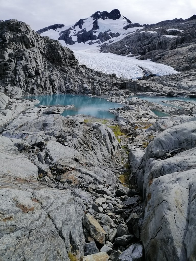
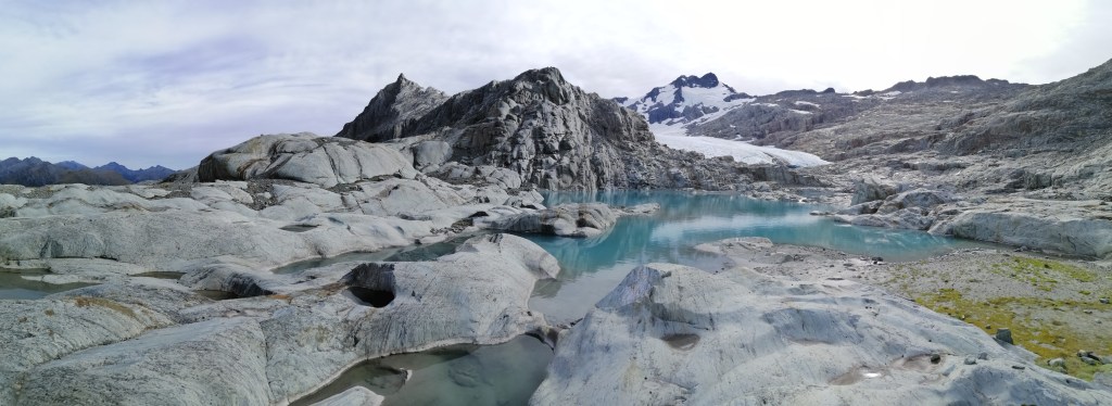
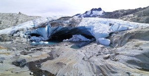
After an hour, I made my way towards the glacier at about 1650m. Crossing the lakes along its edged enabled me to get to the glacier terminal face. How many places can you get close and personal with a glacier in the middle of the Southern Alps? A huge chunk of the ice had collapsed and created an ice cave. Some of the ice hung precariously. It was a just matter of time. The size of the glacier is only evident when standing face to face. Brewster Glacier stretched over 2.5km towards a cloudy sky. The terminal face is over 1/2km wide with a height of over 5m. I was tempted to go into the blueish ice cave. However, with no one around, I hesitated. Melt water flowed out from the glacier into small fast streams cascading over the rocks and drained into the larger lakes below. Being so close to a glacier was mesmerising. Walking to Mt Brewster looked possible. However, without proper gear- crampons and ice climbing gear, it is not advisable. Although cold, I was reluctant to leave.


I retraced my steps back towards the hut. I had to cross the steep slope and into the gully and back out. I looked up at Mt Armstrong in the late afternoon and thought of attempting to the summit. Perhaps another day. I finally reached the hut at 1430. It was a pleasant day walk. I had booked for the second night. However, I decided to track down. The return hike was not as demanding as the previous day’s climb. I weaved through the beech forest and negotiated the steep decent. The weary and tiresome look on the hikers ascending told a familiar story. Their frequent question was “how far is the hut?” Around 1700, I reached fast flowing icy Haast River. Crossed it bare footed one more time, and onward to Wanaka. The weather gods had been good today.

Summary
Brewster track is tough hike as the track weaved through exposed beech roots and a steep terrain. However, the reward at the top is the wonderful views of the Southern Alps, Haast Valley , glaciers and the stunning milky way in the night skies. The unmarked track to Mt Armstrong and Brewster Glacier is challenging but enormously satisfying. Crossing Haast River in the beginning and end is subject to water level. This track to the hut can be done as a day track and return.
