Big Wild Goose Pagoda ( Dacien Temple) was built in 652AD during the Tang dynasty. Today it is 64 m tall. The pagoda shaped tower had been rebuilt several times due to damage caused by earthquakes. The original one collapsed and rebuilt in 704AD and again in 1556. One important role it played was to keep Buddhist sutras, paintings, relics and other structures brought from India into China. Burning incense wafted through the still cold air. There are several squares, courtyards and water features including water fountains around the complex. It is a pleasant place to wander. Sounds of kids playing in the gardens added some pleasant distraction. This pagoda temple is an icon from the early Xian and ancient China. Another iconic building is the Small Wild Goose pagoda, which I had missed. Nearby the temple is a great vegetarian restaurant. About half an hours walk brought us to upmarket coffee shops and bars. However, it was subdued and probably become active in the evenings. A local bus to and from the city centre is easily available. The Bell Tower Hotel is ideally located for transport connections and sightseeing.
Travelling in winter had it challenges but gave a different perspective of traveling. Unfortunately, smog pollution for burning coal is unavoidable in winter. It had been at hazardous level during our travels. Furthermore, the big Spring Festival was just 10 days away and traffic can become congested. Pre-purchasing onward travel like trains is advisable, as we did.
We passed a park on our way towards the City Wall South (Yongning – eternal peace) Gate, we were greeted with a Whitney Houston song I Will Always Love You…….a light and sound show was being set up. Against the wall, huge banners and a stage under construction. Large lanterns were randomly placed. A PA system, large speakers and electronic gadget were being tested for a show, perhaps later in the day. I was quite taken back by the earlier sights as we made our way up the ancient wall. This was a historic moment for us. However! There were more surprises, the set had also been established on the wall. Large brightly coloured lanterns – a mythical horse with a cockerels tail, a yellow chick and many more. We continued to walk on the wall, to our relief, there were no more. Only the ancient Ming Dynasty wall and smog to contend with.
I read somewhere that there is an opportunity to cycle on the fortress wall. This wall was built by previous dynasties but during the Ming era, a bigger and stronger wall was built. Hence the existing Ming Wall. Although the pollution level was very high, at 320ppm, I looked forward to this ride. Past the moat and strangely as we entered through the South Gate We hired bicycles (be prepared to have 200 yuan for cash deposit plus payment) and went on our way in anticlockwise direction. The old outer wall was built during the Sui and Tang periods (around 194 BC). Changan, was the capital of Tang Dynasty. The existing Ming Wall (built around 1370) is only one seventh of the original Tang dynasty wall, which stretched to include the Big Goose Pagoda. It had been restored and preserved over the years by successive rulers. Part of the old wall may be seen in places. This Ming Wall stretches for about 14 km. Cycling was fun, although, the surface is uneven. Unfortunately, due to a heavy smog, visibility was very poor. We could almost see the silhouettes of tall modern buildings outside the wall. There are several main and minor gates, towers, a golden roofed Tibetan Temple along the way. At some walls, there is a steep narrow passage, probably to enable horses and men to travel up the wall. Some gate had several layers of structures. Small museums are also dotted around the wall. The whole walled city was surrounded by a moat. 12 km of cycling in the heavy smog should be done at a leisure pace, to avoid heavy breathing. We exited from the East (Changle – meaning eternal joy) Gate. It was a wonderful experience. I can only imagine the soldiers, horses and noblemen rambling along the walls and the flags fluttering in the wind.
On the glittering side of modern Xian, cafes are dotted here and there. A cup of latte can cost uo to 30 yuan (NZ$6). These places are seen as yuppie or trendy places to be and to be seen. To me, these places offered respite from the hustle and bustle of commerce; the dirt from the thick traffic and temporary shelter from the hazardous polluted air. Some of the coffee was good too. Xian is noticeably clean. Workers cleaned throughout the day and night. Late at night I watched a group of women cleaning the under passes.
Gao Family Mansion, about 400 years old, is the former residence of Gao Yuesong, an official of the Ming Dynasty (1368 – 1644) is one of the best-persevered traditional residences in Xi’an City. It is located on the busy Huimin Street (Beiyuanmen Street) in the Muslim Quarter. Stone lions guard the entrance. Once you enter the compound, the din of the street dissipates, and a sense of serenity prevails. There are several courtyards with ornately carved windows and decorated with traditional furniture. At one courtyard, a permanent opera style stage had been set up and today live music and singing. This experience is a small window to the past traditions. I waited to be surprised with food being offered. Perhaps, so tea to warm up in the cold air. Unfortunately, it was not forth coming. The show was good and entertaining.
The city god temple of Xian, Cheng Huang Miao was built in 1387 (Ming dynasty). It is also called the Capital City God and had looked after the welfare of the city since. Prayers to keep away bad deeds. However, during the cultural revolution, it was not spared. The entrance to this temple was crowded with people shopping either for worship at the Taoist temple or for presents for the coming Chinese New Year. There were candles, fragrant incense sticks, red packets as gifts for the new year celebrations, clothing, auspicious red lanterns and lattice wall hangings, and all the paraphernalia of welcoming the new year of the Dog. It felt more like festivities celebration than worship. Once you emerge from the flea market, tranquility returns and the smell of burning incense and joss stick over powers the smell of smog. The pious and worshipers move from one place of worship to another. There was another congregation huddled on one side of the temple entrance. I was curious. It was a serious game of Chinese chess. Families with kid in tow all visited this temple in droves. Red totems hung on wall with precious prayers and words written on them.
It is difficult to imagine that all roads from and to the East and West passed through the Bell Tower, which has four entrances. Today, in mega developed, and I must say clean metropolis, the Bell Tower I the centre of f huge roundabout. Hundreds of road vehicles are moving every second during the day buses, cars, pedal bicycles, motorised bikes and motorcycles. Then there are the pedestrians.
One of Xians iconic ancient structures is the impressive Bell Tower, built in 1384 by Emperor Zhu Yuanzhang. Its use was multi-functional as defence as well as used for regulating daily life. It marked the geographical centre or central axis of the ancient capital with roads departing North, South, East and West corresponding to the gates since the Tang Dynasties. The wooden tower, which is the largest in China, is 36 meters high. It stands on a brick base 35.5 meters high. Today, in modern Xian, the Bell Tower is contained within a round-about with vehicles spewing smoke and noise. However, viewing from my hotel room in the evening, with lights on, it certainly is an impressive structure. With its elevated brick platform, there was an air of invincibility.
On the streets near the Drum Tower, I met this family, two kids and an adult. They approached me and wanted to practice English with me. This is a familiar experience for me throughout my travels in China. I on the other hand belt out whatever Mandarin I know, and they are impressed. This is my great tool to mix and mingle with the locals. It establishes some rapport and has led me to several pleasant local experiences invitation to meals, into homes, offered transportation and so on. Having some working knowledge of Mandarin is certainly valuable (sometimes it gets me out of trouble).
Another prominent and iconic ancient architecture is the Drum Tower. It was initially built in 1380 during the reign of Emperor Hongwu of the Ming Dynasty (1368-1644). The drums were used to signal time (in the evening) and alarm in an emergency. As its counterpart, the Bell Tower, it is also elevated on a brick base to 34m high. The tower itself is 111m high and is completely made from wood (no iron nail used anywhere in the Tower). The exterior is colourfully painted with a beautiful green glazed tiled roof. Drums are beaten at specific time as a musical performance. Perhaps a nostalgic journey to a past era. From my hotel room, in the evening, it is brightly lit and all the drums on the south side is clearly visible. It is quite spectacular. The Drum Tower is located adjacent to the Muslim Quarter and West Street.
Walking away from the city and touristy centers, you may get to experience a real and laid-back Xian. We wandered aimlessly and encountered some food stalls, markets and street vendors. The locals went about their business. At the butchery, whole pigs hung on hooks. On one street, five birds in cages hung on street wires as people passed by. Kids played on the side streets with no care in the world. Steam floated in the air from a road side bun shop. One of my favorite shop, women selling an assortment of pickled fruits and vegetables. I love walking in the market. They give an indication of the robustness of the local economies. Furthermore, the dynamics of family. Plus, I get to see local produce and sample a few along the way. Although a big metropolis, Xian feels a little laid back and the pace of life pleasant.
The Muslims established here through trade on the silk route since the eight century. However, during the Ming dynasties that they became more pronounced and the Great Mosque was built. I can only imagine huge sacks and boxes of goods stacked on camels and horse backs plodding through on these narrow alleys and pathways. A narrow, pedestrian only alley, Huajie Lane, lined with an amazing array of nick knacks and goods lead the way to the Great Mosque of Xian. . It was built in 742 during the Tang Dynasty (618-907). We passed several courtyards before arriving at the central tower (or perhaps a minaret – Xingxin Tower). It is interesting as it has both Chinese and Islamic influence. It is a Chinese pagoda style architecture with Islamic interiors. The roof is an intricate wood work. Here, there is serenity, as we walked around the landscaped gardens. This site was already in use during the Tang dynasty but eventually established as a place of worship during the Ming era. A series of add on continued to the present day architecture and structure. A fantastic mix of Arabic and Chinese influence. The minaret, to call for prayers, looked like a pagoda. Bearded men with white hats sat behind stall counters; little whispers as a few gathered at the mosques courtyard. Some even spoke Malay language. Another man had been studying in Malaysia. I met a man selling religious items. He was well travelled. When I asked him if I could take a photo of him agreed. Just I was about to click, he flicked his fan! To exit, I went through the gauntlet of souvenir stalls. A little persuasion but no harassment
On the Huimin Street (Muslin Street), we were handed a pamphlet on a shadow puppet show. This show is very popular in Malaysia, especially in the East Coast. It is called Pi Ying in Chinese. Shadow puppets were invented more than 2,000 years ago in the capital Changan (the historic name of Xian) during the ruling of Emperor Wu of the Han Dynasty. The storied often depict Chinese legends and local village stories such as the one we witnessed. The puppets a skilfully made with intricate designs of characters, brightly coloured and sometimes looks mythical. The shadows of the different characters are cast on a white scree using back lit lights. Music accompanied the lively performances created by the puppet master. Although, I did not understand the dialog, the show was certainly entertaining. It did bring me back to my childhood days. Very nostalgic and it left lasting a memory. Bookmarks of some of the characters make fantastic memorabilia to take home.
Xi’an is the capital of Shaanxi Province and is one of the four Ancient Capitals of China. Then, during its early metamorphosis, known as Changan, was the first capital of the Qin Shi Huang the man who united the rival feudal lords into one country. Located in North West China, it is through Xian that trade began with the west, the Middle Eastern states of the Arabic world. The starting point of the famed Silk Route to the West. Besides this, in my early school history lessons on China, I became acquainted with Qin Shi Huang Di, reputed to have unified China. The Emperor is also the character that created the iconic Terracotta Soldiers. I was quite excited to be in this renowned city of the by-gone era. The smog pollution continued from Pingyao to Xian. It was a long drive from the modern train station to the heart of Xian. The old city encircled by a Ming Qing 12m wall. However, unlike Pingyao, apart from the wall and exceptions of a small enclave of old Xian, everything was modern and towering buildings into the dark polluted air. The modern city roads had breached the wall and infiltrated into the old walled city. Today, metal, concrete and glass on show to rival any metropolis. In the evening, neon lights beamed from shopping malls. We stayed in the middle of it all, just across the softly lit Bell Tower and nearby Drum Towers. Both remnants of a colourful and historical past dynasties that ruled China. I wanted to get out and explore.
Near and around the elegant Drum Tower is a remnant of old Xian the Muslim Quarter, just below the Drum Tower onto Beiyuanmen Street. Generally referred to as Huimin Jie or Muslim Street. It is packed with street food vendors and behind them, restaurants. It is a hive of activities sales pitches; spicy aromas filled the cold air; raging flames from gas burners turned woks red hot and steam rising from bubbling soups. As the biggest festival in China is around the corner, Spring Festival or Chinese New Year, there is a sense of festivities on the streets. The narrow cobbled stone street is packed shoulder to shoulder with people.
Goat carcasses hung on rods, being stripped away little by little. Hygiene may take a new meaning here. Time for a late lunch of the Xians distinctive and favourite – Yangrou Paomo (Crumbled Unleavened Bread in Mutton Stew). It is quite a process to break down the bread into tiny pieces (takes a while as the bread is hard). However, Lee Cheng and Navindd testified that the taste is delicious. I settled for another popular north western food – the cold noodles (Liang Pi). Noodles are seasoned with a tangy, spicy savoury sauce and julienned cucumber. Long queues formed at the Mutton burger (Ronjimo) stall. Another popular snack is the steamed stuffed bun. The bun is stuffed beef or mutton mixed with the soup (from the bones of sheep or cattle). People queued in long line at this stall.
This morning, we headed to the one of the most iconic man-made structures in the world the Xian Terracotta Warriors Museum. A local bus took us directly to the museum. I was quite excited as this has been one of the sights to see. We engaged a guide to get a better understanding. The are several pits, all under covers, to explore. As we entered Pit 1, the stage opened an amazing gallery of clay soldiers and horses, all line up in formation. It was quite spectacular. Imagine, over 2000 years old! Pictures are great but being here is simply spell-binding. The sight is just overwhelming, let alone looking at each individual piece. There are over 6000 pieces (only 2000 excavated). They are life-sized, and each individual had their own unique looks. The soldiers complete with body armor consisted of infantry, calvary, officers, archers and chariot warriors. All arranged in a battle formation. Emperor Qin Shi Huang (210209 BCE) ordered its construction, depicting his existing armies, to accompany him in the afterlife.
The size and the workmanship alone are enormous. To achieve this feat must have taken years (about 40 years) of dedication (perhaps forced labour) to complete. All were handmade, thus resulting in the uniqueness of each individual soldier. The body parts were made separately and assembled later. We know why, but how? – the skills of the artesian, the processes in making the terracotta structures, the pigments used that lasted the test of time, the management, perhaps ruthless, required to complete the project. All these questions can be contemplated while walking alongside these silent wonders. However, Qin Shi Huang died before its completion.
This site was accidentally discovered by a farmer in 1974. On discovery, some of the statues were colored. However, due to exposure, the colors had faded. Many statues are still buried to conserve the colors and hopefully displayed in its original glory (with future preserving technology). The other pits are smaller but contain similar artifacts. In places, broken pieces can be seen to give an idea the conditions there were in when found. It must be a giant jigsaw puzzle to put them all together.
At the back of the pit, many statues were painstakingly being labeled, reworked, cling-wrapped and restored to its original condition. The display of 2000 figurines is already huge. Just imagine if all 6000 were exposed!
In the nearby exhibition hall, we can get personal with the warriors. All encased in glass and brightly lit. The delicate details of the face and expression, the full regalia of the body armor and its dimensions. All the terracotta soldiers found had collapsed except one, the kneeling archer. The original pigment can be seen. Now, it is on display at this hall. Another highlight here is two beautifully crafted bronze chariots. There is a sense of achievement and contentment having seen one of the greatest archaeological find. A testament to mankind’s ingenuity, desire, determination and ambitions.
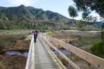
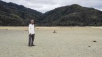
Day 1, Nov 23, 2018 – Marahu to Anchorage (12.4km)
Departed Nelson at 7am with the temperature around 7°C. This weeks’ weather in the South Island is unusual, meaning some bad weather is round the corner and may affect our track. We were prepared for it with appropriate gear. Arrived at Marahu by shuttle bus from Nelson around 8am. Once all the paper work was sorted at DOC office, we handed over our packs to be transported by water taxi. We were off around 8.30 am on our coastal track which started immediately opposite the office. It began as a cool day with strong shine just edging over the lush green mountains.
Day 1- Marahu to AnchorageDay 1- Marahu to Anchorage
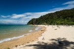
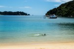
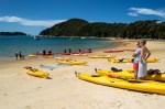
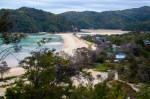
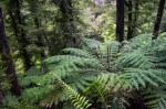
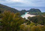
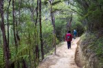
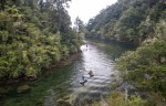
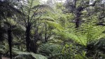
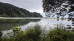
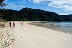
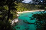
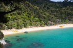
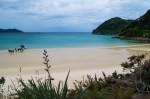
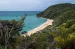
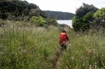
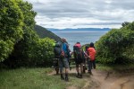
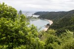
The track is well defined and started as wooden planks over a marsh. Today’s hike would take us about 4 hrs covering 12.4 km. A few kayaks on the water off Tinline Bay. Took a detour towards Tinline Nature Walk. Native bush with small but fast flowing streams. Arrived at secluded and a little stony Apple Tree Bay around 11 am. The sun shined brightly. Across the water are smaller Fisherman and Adele islands. It was a beautiful day. Walking amongst the native bush, mainly beech forest and kanuka tress, was exhilarating. Silver and black tree ferns provided variety in the bush. The track meandered inland mainly under the canopy of trees. It offered shade. The gradient was gentle, suitable to most average hikers. Detoured towards Pitt Head. Fantastic view of emerald green and turquoise water of bays, beaches and coves. Water taxis and boats shuffled around transporting people, kayaks and luggage to various spots along a wonderful coast. Something unusual was, there is no wind at all. On the water, not even a ripple! Avid kayakker’s paddled gently on the blue – green waters. As we approached Anchorage, the tall tree canopy gave way to shrubs as we climbed uphill. Here, it offered 360 degrees view of water and mountains. Finally, we arrived at beautiful Anchorage Bay around 2pm.
Day 1- Marahu to Anchorage
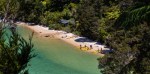
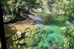
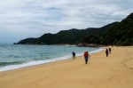
An inviting crescent golden sand beach lay before us. The beach was crowded with trampers and mostly day trippers via water taxis. On the water, boats and kayaker were busy. We picked up our pack from the beach. Our hut was cozy and with 24 bunk beds. From here, headed to Cleopatra Pool. The light on the water along the way was amazing. It was unbelievably clear. The refreshing pool had a natural slide (perhaps for slimier and smaller bodies). The water was cold. The return walk was 1.5 hrs.
Day 1- Marahu to Anchorage
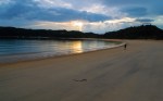
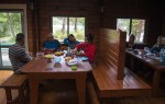
At dinner time, I was quite excited to cook with my newly purchased pots and stove. All the huts on this track only provide shelter, a bed and mostly unpurified water. No showers nor power either. There was a camaraderie amongst the hikers. Most were foreigners. Later in the cloudy evening, I strolled on a empty beach only to the sound of water gently lapping on the shore. Still no breeze.
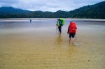
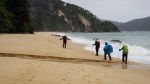
Day 2, Nov 24, 2018 – Anchorage Bay to Bark Bay (8.7km)
After a quick breakfast, we left calm Anchorage Bay around 0630. The sun was just peeking through thick clouds. Oyster catchers and cormorants were the only residents on the beach. The reason for the early departure is to walk across Torrent Bay Inlet at low tide. This would save us an hour’s hike on the high tide track (11.7km). Therefore, when planning to hike in the park, knowledge on tide time is critical especially on Day 4, across Awaroa Bay Inlet. There is no high tide track.
Day 2 – Anchorage to Bark BayDay 2 – Anchorage to Bark Bay
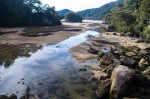
There is an open expanse of sand and mud at Torrent Bay Inlet. A stream of water flowed out to sea that must be negotiated. Probably from Cleopatra’s Pool and Torrent River. At places, it was just below my knee. We waded through the inlet in about 20 minutes. That led us through a quiet Torrent Village. They were perhaps holiday homes. It was a substantial village. From here-on the track meandered inland passing through several streams. The lush forest kept hiking cool.
Day 2 – Anchorage to Bark Bay
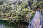
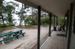
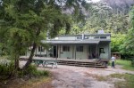
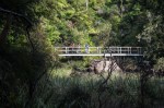
Around 9am, we crossed a wonderfully clear Falls River via a suspension bridge. Sunken logs clearly visible under water with old man’s beard (lichen), hung off trees on the river banks. Towards the later part of the track, it drizzled lightly. It became darker under the trees, shrubs and tree ferns canopy. Having left early this morning meant we arrived early at our hut at Bark Bay, around 1115. It was high tide. Collected out pack from the beach near the camp sites. It was slightly wet from the late afternoon drizzle. Bark Bay hut had 34 bunks. I took a quick cold shower, courtesy from a hose. Time for some lunch and rest. The day stayed gloomy and the sky grey. The resident DOC staff, Phill, was a humorous guy with lots of information and wise cracks. We managed to get a ‘private room’.
Day 2 – Anchorage to Bark Bay
It became routine to start dinner early. Lights through solar power lit the dining room intermittently. I had packed some miso with noodles and rice with ready to eat Indian meals. As per day 1, there were lots of meal sharing. Some of us had packed too much food. I strolled out to the bay, at low tide, walked across soft sandy beach. Some hiker had collected mussels off the rocky coast for dinner! Still, there was no wind! The surrounding forest was still as it was well sheltered. Early to bed but no need to catch the low tide the next day. Both low tide and high tide tracks took about the same time to walk. Sleep in huts is never easy as hikers sleep in close proximity. Ear plug might be a solution.
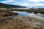
Day 3, Nov 25, 2018 – Bark Bay to Awaroa (13.5 km)
Sleep was partial in the hut. Breakfast was chapati with condensed milk and coffee, carbohydrates for the morning walk. From the hut, I could barely make out the orange signage indicating the low tide track. All along the track, there are signage and markers (triangular or round), especially along the coastal track. The track is well maintained. We left around 0730. Deposited our packs on the beach for collection by water taxi to our next stop, Awaroa. We took the high tide track, which led inland. The day was cloudy but no rain or wind. The air was muggy and cool under the coastal forest canopy. A sea of Manuka trees and tree ferns hindered views of the sea.
Day 3 – Bark Bay to AwaroaDay 3 – Bark Bay to Awaroa
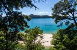
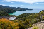
Crossed the Waterfall Creek via another suspension bridge. Water swiftly flowed over boulders towards the sea. Along the track, you would see yellow wasp traps and other traps set up by DOC. We eventually descended towards Tonga Quarry. Little remains of the granite quarry reminded us of past settlers’ life. Across the water, Tonga Island. Now, seals had taken refuge here. After another bush walk, views of idyllic Onetahuti Beach emerged. Rocky outcrops, emerald green water and golden sand beach made it an inviting proposition. Kayaks laid on the beach. A great place for lunch.
Day 3 – Bark Bay to Awaroa
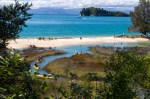
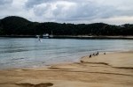
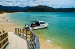
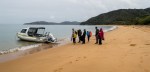
We continued crossing a Maori bridge and an all tide crossing boardwalk. This diversion meant, no more waiting for the tidal crossing on Onetahuti Beach. From the beach, it is uphill walk into the Tonga Saddle. We reached a signage, Awaroa Lodge and Awaroa Hut. We head towards Awaroa Lodge as our packs are deposited at Awaroa Beach, next to the lodge. This is private land, a non-DOC track. If the timing for a low tide crossing is possible, take this track. Perhaps have some tea and lunch at the Lodge while waiting for the tide to drop. We arrived around 1200, collected our packs but made a ‘big’ decision. Although we had bookings at Awaroa Hut, we decided to stay at the lodge for the night. Hot shower and a fancy meal. A little indulgence to sample all of Able Tasman Park. There is a pizza outlet as well. Stunning Awaroa Beach was recently passed on from private to public ownership through crowd funding. Water taxis collected and dropped off passengers, day trippers and lodge customers. A big day tomorrow, to cross the Awaroa Inlet. There is no high tide option!
Day 3 – Bark Bay to Awaroa
Nearby, there is a small grassy airstrip to bring the well-to-do customer to the lodge. Planes have been flying in and out throughout the day. Finally, the ‘unusual’ weather that hit South Island descended on us. At dinner time, it poured heavily, and it continued through the night. We carefully packed all our packs as from here-on, there is no public water taxi service. At least, a comfortably bed tonight.
Day 4, Nov 26, 2018 – Awaroa to Whariwharangi Bay (16.9 km)
We woke up to the sound of rain. Today is critical that we cross the Awaroa Inlet at low tide. There is no other option. Bags water proofed, rain gear on (including a poncho) and with a spirit of adventure, we headed out towards Awaroa Hut. We left around 0630. Low tide crossing can be made with two hours on either side of the lowest level. Need to make allowances for the main crossing, that would take about 30 minutes. . First, we walked on the grassy airstrip. We could all be easily sported with our bright rain coats. The first crossing is a river crossing. Then onto the beach towards the hut. We stopped at the hut to make breakfast and a sense of ‘comradeship’ developed as we met other fellow hikers on the same route. In a short time friendship is bonded. Everyone was preparing for the low tide crossing. We packed and headed out around 0745. High tide would come in around 0830. Bare footed, we walked across fast flowing streams from ankle to knee depth. Beware of crustaceans and soft mud. Low cloud hung over nearby mountains. There was a breeze.
Day 4 – Awaroa to Whiriwharangi
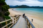
Once across, we scrambled in the, fortunately, light rain to get our boots on. Tree canopies provided shelter from the rain until Waiharakeke Bay. We were exposed to the elements. The sea was a little rough. I had packed too much, and it began to weigh on me. Eventually, we arrive at Totaranui around 1100. This seems to be a hub of activities. Camping grounds, road transport to Takaka and Nelson is available plus water taxi service. Tomorrow, we will return to Totaranui to catch a water taxi back to Marahu. There is also a museum about Able Tasman National Park. It was a little reprieve from the continued rain. In a designated hut, we prepared lunch. However, watch out the mischievous Weka birds that has affinity to anything packaged. Food basically. Please do not feed the Weka as there is plentiful in the surrounding area.
We took the high tide track pass historic Ngarata Homestead and re-entered the forest. There is an alternate route via the Gibbs Track. Soon we were descending again towards the coast at Anapai Beach. The rain ceased around 1300. It was a relief. It was a long track on the beach and hike inland again to dense forest. There were great views of Anapai Beach. We then crossed several hills and passed a grassy field towards an orange triangular track marker to Mutton Cove. This is a camping site. The sea was still rough. From this point, we head inland and direct route to Whiriwharangi Hut.
Day 4 – Awaroa to Whiriwharangi
The climb was uphill. There is a great viewpoint looking down at the bays and rugged coastline. From her-on is downhill, which pleased me. We arrived at this 1896 Whiriwharangi Bay Hut around 1645. The hut has 20 bunk beds. There was a sense of ‘having arrived’ at the hut. There was laughter and warmth from the fireplace. Now we can truly appreciate the walk, the landscape and the eco-system with time on our hands. We removed all the wet gear and footwear to dry out. Time to unwind with a nice hot cup of condensed milk coffee. Later, a proper but cold shower. From here, hikers may depart to Wanui (and onward road transport) or like us back to Totaranui. It has been a long day. Our final meal prepared on my no-so new pots and stove.
Day 4 – Awaroa to Whiriwharangi
Day 5, 27 Nov, 2018 – Whariwharangi Bay to Totaranui via Separation Point (10.5 km)
Today is our last day of hiking. Returning to Totaranui to catch a water taxi back to Marahau and onward by shuttle to Nelson. It did rain last night but looks promisingly good this morning. I strolled the compound around 0600. A single Tui bird fed on nectar of a flax plant.
We left around 0830 and wandered around isolated Whariwharangi Bay. A gradual climb brought us to a junction. One path leads directly to Totaranui (later with another option, that is,via Gibbs Hill). This is a better option if wanting to walk via Gibbs Hill and not the other way (ie Totaranui to Whiriwharangi via Gibbs Hill). The accent is difficult especially in wet weather. The second path is a detour via Separation Point. Today, we decided to head to Separation Point.
Day 5 – Whiriwharangi to Totaranui
[caption id="attachment_9864" align="alignleft" width="300"] Day 5 – Whiriwharangi to Totaranui
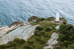
We came across many kill traps set up by DOC to get rid of introduced pest like rodents. Flowering Lupine can be found in small clusters. It was a gradual walk and from the hills, we had a fantastic view of Mutton Cove. On a narrow path we edged towards Separation Point around 1000. The water was absolutely clear. At the bottom of the rocky beach, fur laid sunning on the rocks while some swam happily in the water. On a steep path, I descended to the edge of this rocky outcrop. Lots of flax, prickly plants and gorse bushes along the path. Besides seal, gannets also make this isolated place home, when in season. Beyond this point is the Tasman Sea.
We retraced our walk steep uphill climb and back inland. Soon we were back on the sandy coast, Mutton Cove. We had to negotiate some rocky outcrops to proceed. A giant male seal choose to rest on the rocks. Carefully, with one eye on the seal and the other on the shifting rock, we managed to continue out track along the coast. Soon we found the familiar Anapai Beach.
Day 5 – Whiriwharangi to Totaranui
Finally, we arrived at Totaranui around 1330. We rested at the museum and waited for our water taxi pick-up. Plenty of sand-flies. We boarded at 1500. It was a fantastic and smooth ride. We stopped over at Tonga and Adele Islands. A small colony of fur seal had taken refuge here. The whole boat was loaded onto a tractor-trailer and hauled back to Marahu. Arrived at around 1630. After a long day, we returned to the comforts of a modern apartment in Neslon.
The Able Tasman National Park is managed by the Department of Conservation (DOC). There is plentiful of information and booking opportunities on-line. Huts must be booked in advance to avoid disappointments during peak seasons. This track is open all year round (no snow in the coastal region, yet!) Water taxis are at your convenience which enable you to get into the park at various destinations and time spent. Insect repellent is advised to keep sand flies in check. Travel light with all-weather gear, food and cooking utensils (including stove). Beware of the tidal timings as it may be crucial for onward travel (especially when no high tide alternative track is not available). Daily information is updated in all the huts by the rangers. Talk to them as they are local with wealth of information. Enjoy the spectacular tidal change, lagoons, fast flowing streams, isolated cove, native forest, emerald-green and turquoise water and beautiful golden sand beaches. Throw in the birds and wild life, Able Tasman Coastal Track is simply amazing.
5 day hike on the Able Tasman Coastal Track in November 2018. Stared at Marahu and finished at Totaranui. Then returned to Marahu by water taxi. Beautiful lagoons, lush native forest, emerald green and turquoise water, tidal inlets, wild life, creeks and rivers and lots more.


 Gao Family Mansion, about 400 years old, is the former residence of Gao Yuesong, an official of the Ming Dynasty (1368 – 1644) is one of the best-persevered traditional residences in Xi’an City. It is located on the busy Huimin Street (Beiyuanmen Street) in the Muslim Quarter. Stone lions guard the entrance. Once you enter the compound, the din of the street dissipates, and a sense of serenity prevails. There are several courtyards with ornately carved windows and decorated with traditional furniture. At one courtyard, a permanent opera style stage had been set up and today live music and singing. This experience is a small window to the past traditions. I waited to be surprised with food being offered. Perhaps, so tea to warm up in the cold air. Unfortunately, it was not forth coming. The show was good and entertaining.


 Day 5 – Whiriwharangi to Totaranui