Track Information
Day 1 – Glade Wharf – Clinton Hut
Day 2A – Clinton Hut to Mintaro Hut
Day 2B – Mintaro Hut Mackinnon Pass to Mintaro Hut
Day 3 – Mintaro Hut to Glade Wharf
Track Information
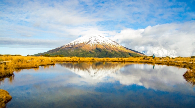
Milford Track is located in the unique Fiordland in New Zealand’s South Island. It is considered one of New Zealand’s Great Walks. Read about my hikes in Abel Tasman Coastal Track , Kepler Track and Routeburn Track in previous posts. You can also see my Milford Track photos
-an early European explorer described Firodland as “utterly useless except for mountaineers”. Hence, that’s why it is still so pristine –
For independent hikers, registration and bookings are made through the Department of Conservation, Fiordland National Park. Booking is not only essential, book early as it is popular particularly between December and March. Milford Track had been sold by NZ tourism and is extremely popular with foreign tourist. I suggest booking on the shoulder season – early November and April to avoid the crowd. All booking must be confirmed at the DOC offices either in Queenstown or Te Anau prior to starting the track. Transport can be organised by Real Journeys and Tracknet. The Fiordland weather is unpredictable. Be prepared for mainly for rain and gusty cold wind.
This is normally a one – direction hike over four days. However, due to exceptional high rainfall in February, parts of the track including bridges had been damaged. The only road into Milford Sound had also been damaged. The 53.5km Milford Track had been re-branded as Southern Milford – Mackinnon Experience (52.3km). This required us to trek all the way up to Mackinnon Pass and return the same way in three days.
Day 1 – Glade Wharf – Clinton Hut
Departed Te Anau at 0945. It began as a cloudy day as we drove to Te Anau Downs to catch a ferry to our starting point of the hike.
There had been no rain in the Fiordlands for three days and it continued today. One local man said it was a drought. It was indeed, being one of the wettest places in the world. The bus journey to Te Anau Downs passed through pasture and farmlands. The morning sun rose behind the Earl Mountains and cast a beautiful lime green light on the moist pasture grasses. On the west is the shimmering Lake Te Anau. Closer towards Te Anau Downs we passed through native restored bush covered with spiky golden tussock grasses.
Start at Te Anau Downs
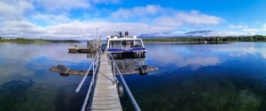
After an hour’s drive we arrived at Te Anau Downs jetty – the launching point to hike the Milford Track. This is the midpoint of the 65km North – South length of Lake Te Anau. The views are stunning. With rolling hills and blue -green mountains on the east and west, beyond the deep sapphire blue lake, the Kepler and Murchison Ranges rose to over 1600 meters.
We boarded the 10.30am Fiordland Express catamaran with several other hikers and day trippers. It was still cool as we prepared to depart. With hot coffee and sweet biscuits, I settled in for the journey. Soon after we took off, the reality of the cold winds hit us. I quickly zipped up my newly purchased yet-to-be-tested rain jacket.
With the Kepler Ranges behind us, we forged forward to unknown mountain ranges. A few islands are dotted around this vast freshwater glacial lake. One of them had Mackinnon Memorial Cross planted. The captain slowed down for us to pay our respects. Quintin Mackinnon disappeared on Lake Te Anau in 1892. His body was never found and presumed drowned. A small iron cross marked the site of the wreck.
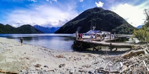
Distant bluish mountains became more pronounced. We passed fiords and scarred mountain slopes. The wildness of the Fiordand began to appear. Like the lake itself, these mountains are also carved out from glacial actions. They seem impenetrable. Yet, thanks to men like Mackinnon, we too can take a similar journey through these majestic and remote mountains. Early Maori first travelled this route to get to Piopiotahi (Milford Sound) to collect greenstone (pounamu). After an hour plus, we arrived at Glade Wharf, the head of Lake Te Anau – the start of the Milford Track.
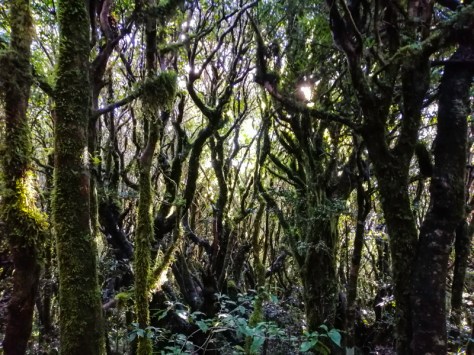
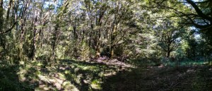
To protect the park, our shoes are disinfected at the jetty. With the obligatory pictures at the Milford Track signage taken, we set off. Today’s trek is short, just 5km to Clinton Hut. There was no rush. The trek immediately entered the beech forest. The walk, mainly under tree canopies, was soothing especially with the scorching sun. The ferry departed shortly after. The last of civilisation. The well laid stony track took us deeper into the forest. The familiar flora of the fiordland appeared – soft velvety ground spaghnum moss and hair-like lichens hanging from tree trunks and branches. I recognised totara, red beech, ferns and comprosoma plants. The filtered light through the hanging old man’s beard is striking. Parts of this forest still retained its primeval uniqueness. It is as old as in Gondwanaland.
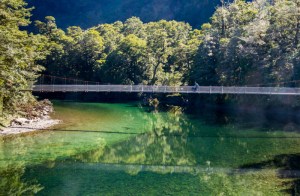
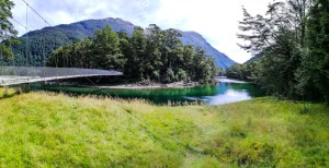
Once we emerged out of the tree canopies, we entered a grassland. On the left is the slow flowing Clinton River. In the middle of the grassland – luxurious Glade House Lodge (used by hikers from the expensive guided walks) with mountains as the backdrop. Today’s short walk awarded us with plenty of time to wander. The shallow blue-green river flowed under a long suspension bridge. Trout thrived in these cold waters. A paradise duck just splash-landed on the water.
We crossed the first and long suspension bridge. Clinton River displayed several hues of colour ranging from emerald green to blue. Yellow algae on the rocks glowed in the shallows. The lush rainforest reflected in it’s crystal-clear waters. It was a serene setting. The bridge swayed with every step as we made our way across.
Clinton River
The river was absolutely stunning and inviting. It was cold though. The well laid track followed the bank of the Clinton River. Sunlight filteted through the beech canopy. Native birds like Tui, Robin and Fantails greeted us along the trek. I even spotted a Bell bird. At the confluence of Neale Burn and Clinton River, there were great views of Dore Pass – a range of mountains. Bare on top with lush vegetation below.
A side-track took us on boardwalks over a protected wetland. It is a fascinating place, with Mt Anau as the backdrop. Sphagnum moss covered ground is dotted with a reddish carnivorous plant – Sundew (Drosera genus). This is a fragile environment. Other bog plants include liverworts, shrubs, sedge, rushes and lilies. At the edge of the bog are a stand of juvenile silver beech trees.
Not long after, we arrived at Clinton Hut. It was a hot day. Like most trampers, once arriving at a hut, the first chore is to secure a bed. The hut warden, a lanky Ross, was busy doing maintenance work. He reminded me of Gandalf – the wizard from the Harry Potter movie. We decide to settle in with lunch and a wander around. The river is nearby.
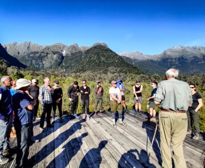
Ross gave a talk on a raised platform behind the hut. The views of the surrounding forest, wetlands and mountains were outstanding. Ross, armed with a wooden staff, expounded his knowledge on the flora in the vicinity of the hut and river – including its medicinal use. It is one of the most interesting talks by a DOC hut warden.
The Clinton River flowed swiftly over rocks and moraines. I spotted a rare Whio (Blue Duck), feeding in the fast-flowing river, oblivious to our presence. The colour of the river is amazing. I was in disbelieve that this is Fiordland weather – blue sky, hot and clear day! A place which received over 200 days of rain. Judging the water level, the dryness of the track and surrounding vegetation, it had not rained for a while. Although it is not the best walking weather, Fiordland has a special beauty during or after a rain. Well, this is only day 1.
We tied the laces and hung the boots on hook outside the hut. This is to prevent the naughty Kea (alpine parrots) from ‘stealing’ them. There are no showers in these huts but toilets and running water is provided. Inside the hut, it is a hive of activity – pots clanging, steam and cooked food aroma filled the cosy room. More hikers arrived from the later boats. It was a mixed bunch of locals and foreigners. The hut was only 60% filled. Milford Track is highly sort after by foreigners since someone said that it is the “finest walk in the world”. Mass tourism, like in Queenstown, has its negative effects. Locals cannot be bothered to ‘chase’ the booking. Furthermore, there are other track options and less crowded. Milford Track has a reputation of being the dirtiest resulting from uncaring tourist. Although toilets are provided, they think it is permissible to ‘shit’ anywhere (understandably, in some cases unavoidable). This unwanted behavior has marred this pristine environment.
Like in other DOC huts, there is always a sort of camaraderie amongst the hikers. The groups and loners mingle with the experienced and novices. Everyone had a story to tell. Later in the evening, Ross returned to give the obligatory hut talk. He is a delightful character. With good weather forecast, inside information on ‘things’ to see along the way, he recorded our bookings. After our ready-to-eat Indian meals, we slept early. The stars were out. Nearby is a glow-worm grotto. I gave it a miss. Doors opened and shut; floorboards squeaked with heavy footsteps; bunks creaked as bodies turned inside sleeping bags and plastic mattresses. It is always uneasy for me being a light sleeper. I was quietly hoping to hear a Kiwi bird shriek in the nearby bush.
Day 2A – Clinton Hut to Mintaro Hut
Breakfast is something to look forward to. Not only to prepare the body but also the mind on today’s hike. We left early around 7am, considering that it would be an extended walk. Today’s walk will cover 26.5km (including the return hike to Mackinnon Pass).
It was still slightly dark outside. I managed to check out the glow worm grotto. They still emitted light but barely visible. No Kiwi bird cries either. Snorers and ‘movers’ kept me awake. The track continued along Clinton River heading northwards. Ross mentioned to look out for an old telephone post. I missed it but managed to spot some insulators stuck into trees. These are the remnant of the old telephone system linking the huts. At this stage, the track was easy and under tree canopy.
Nearby mountains reflected on the emerald green water and evidence of uprooted trees can be spotted sporadically. The forest is a mixture of Silver Beech, broad-leaves and ferns. Just before the 5th mile, the North and West Clinton Rivers merged. The track moved west from hereon. More open area began to appear. A couple of Kereru (Pigeon), the affable Robin and Bell Birds made their home here. The mountains opened up further.
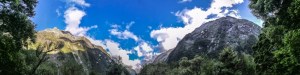
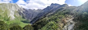
As we approached the 7th mile marker, the bush weaned, and an unexpected clearing appeared. A expansive view of the U-shaped valley opened up. This is the beginning of the Clinton Valley. On both sides of the track, mountains, some with snowy peaks, rose perhaps 1000 meters vertically into the blue sky. The half-moon was still in the sky.
We made good progress. However, the distance that lay ahead played in my mind. Always calculating if we had enough daylight to reach Mintaro Hut and press on to Mackinnon Pass and return to the hut. It was certainly an uneasy state of mind that is not warranted under the normal four-day hike to Sandfly Point (at Milford Sound). We pressed on. I imagined the number of impromptu waterfalls on the mountains if it had rained. Another unusually dry and sunny day in Fiordland. The track is now through scrub-land. The Clinton River was distant, closer to the mountains.
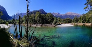
Ten minutes later, in the valley, we spotted still water that reflected the mountains. This included the Pampalona Ice Fields. Trees, including Silver Beech, had been washed away due to landslide. This created the normal flow to be disrupted and a Dead Lake was formed. The water is darker with organic matter leached from the dead trees. Trout and eels thrived here. Perhaps, someday, with heavy rainfall, this lake may re-invent itself.
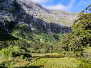
Past the Dead Lake, we re-entered the beech forest. Beyond the bush line, on the slopes of a bare mountain, a series of cascading waterfalls – Hirere Falls (about 100meters). Due to the drier weather, the flow volume was low. It resembled a white shoelace. The Hirere Shelter and toilet is tucked under the trees. At the top of the mountains, a little snow. We approached a beautiful part of the forest – the bluish Clinton River with lichen covered forest. I spotted a Kereru (pigeon) and a Tui. It was serene and very primeval.
It is in places like Clinton Valley where rain would have transformed the view – literally with 1000 waterfalls on either side of the mountains. We must be contended with the few we have today.
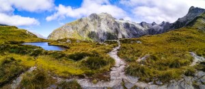
A single Robin perched on a Silver Beech tree branch, kept us company. The trees here are slightly shorter. Around 10 am, we arrived at the first viewpoint of Mackinnon Pass. The beech forest thinned out and opened into a second canyon mainly with shrubs. Not far away, we arrived at detour to Hidden Lake. The views were stunning. Grasses grew on the sides of the track.
Hidden Lake
We don’t want to push too hard that we become tired by the time we reach Mintaro Hut and little gas left to hike up to the pass. If too slow, the danger is hiking in fading light.
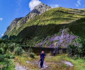
At Hidden Lake, the mountain was half covered in shadow. A small volume of water, like a thin ribbon, cascaded down into a dark lake. The water is icy cold. A pleasant detour indeed. Looking back, we have come a long way into the middle of the valley. It is in places like this that one lingers longer. About 30 minutes later, another signage – Prairie Lake. All of us, wanting to get to Mintaro early decided to carry on.
The track seemed to pass through pockets of beech forest along the banks of the Clinton River. I heard some sound. Three rare Whio (Hymenolaimus malacorhynchos) – Blue Duck, just landed on the bluish cold water’s surface. It was interesting to observe these birds in their natural environment. Whio are endemic to New Zealand, a vulnerable species and possibly facing extinction. Currently, the numbers are around 3000.
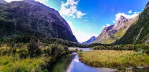
Lime green lichens hanging from tree branches, the turquoise blue river, the white pebbles and the lush multi-hued green forest were all very enticing. This is the magic of fiordland. Finally, the beech forest revealed a second valley. Here it is populated with grasses – like a prairie. It also presented fantastic views of the entire valley. Mountains rose to over 1000 meters on either side as we made our way through the grassland. A single duck foraged for food in a slow-moving stream.
We decided to have lunch in this scenic spot at Prairie Shelter. Unfortunately, the sand flies were furious here. Even with my repellent on, these nasty flies managed to find untreated spots. I hurriedly eat lunch and moved on. It is essential to bring insect repellent. A little Weka wandered around looking for a meal.
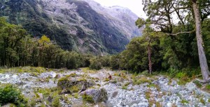
It took me almost two and half hours to cross Clinton Valley. Around 1145, we reached the Bus Stop Shelter. Beyond here is a very rocky climb over Marlene Creek. This is a dangerous crossing in bad weather. Best to stay in the shelter and wait out the storm or flooding. The climb can be treacherous. I crossed a movable metal bridge where only a trickle of water flowed in the creek. Red and green mould covered some of the rocks. The surrounding is littered with colourful wildflowers .
Some pest traps lay on the grass. We re-entered the beech forest and passed the Pampolona Lodge used by the guided walks. This is a great spot to see both the views towards Mintaro hut and the journey we had taken via the Clinton Valley.
The track ascended towards St Quintin Falls lookout. Beyond the mountain range is Mackinnon Pass. Heavy cloud descended upon the mountains near the pass. Above the fall, a small ice fields, mostly covered in clouds. As we progressed, we entered another valley. It was denser with vegetation and steep mountains. Clusters of ferns appeared on the sides of the track. It was a long walk as we passed the 13th mile marker. The day was still bright with blue sky.
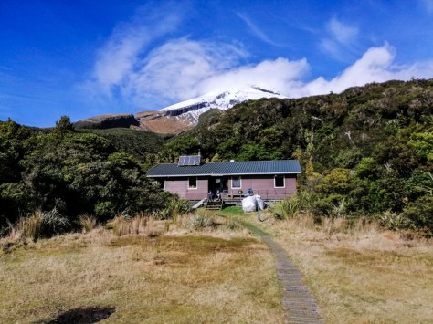
We arrived at Mintaro Hut around 1320. We had walked 16.5 km so far. Our journey today had not ended. On the normal Milford Track, this is the end of Day 2. However, with the revised route, if we wanted to see Mackinnon Pass, we must do it today. I felt rushed. We sorted out our beds, chucked our packs and had a quick snack. After 20 minutes, we continued our hike. There were not many hikers here. Perhaps, they had all departed. Unlike my group of senior hikers, a group of young local hikers were in no rush. I was sure they will pass us soon.
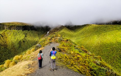
Day 2B – Mintaro Hut to Mackinnon Pass to Mintaro Hut
We headed to the hardest part of the hike – to Mackinnon Pass. Mintaro Hut is at 700 meters and the highest point at the pass is at 1154 meters. Today’s hike will be about 500 meters height gain. The initial part of the track is through the rainforest. We passed a serene Mintaro Lake. Spring water appeared to fill the lake. There was not much time to explore. Such was our itinerary. We crossed a swing bridge over a dry and rocky Clinton River. Here, the river was not as majestic as downstream.
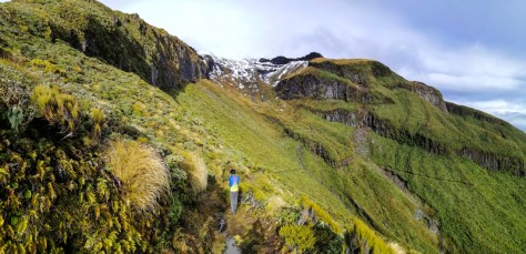
The track was well laid track through the forest. Someone was cutting grass with a trimmer. It turned out to be Andrea – the warden at the Lake Howden Hut on the Routeburn. After a steady climb, the bush gave way to an alpine terrain (at 900 meters plus). The gravel and rocks laid track gave way to stony uneven track.
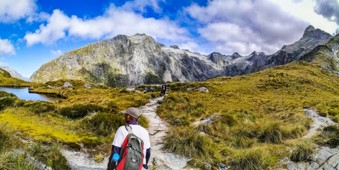
The track zig-zagged up. I was slow at this point. Fortunately, I did not have my large backpack on me. I would be truly knocked out. With progressive ascending, the views evolved. The sun shined brightly and the sky blue. It was stunning. A rare occurrence in Milford.
Looking down, was the green Clinton Valley and in front a bowl-shaped valley – Nicolas Cirque. This valley had been gauged out by retreating glaciers. Very little pockets of snow and ice remained. One slope had heavy scaring resulting from a recent landslide. Several trails cut vertically on the slopes. These are left behind by streams during downpours and a rocky riverbed can be seen snaking out of the valley. This would then feed into the Clinton River. No wonder, the river we crossed earlier looked dry – no rain. Walking carefully on the movable large pieces of rock, we ascended.
Alpine plants populated the slopes. A curious Rock Wern (Piwauwau), one of the rarest alpine dwelling bird species, darted between the plants. This included the Mountain Daisy (Tikumu). I caught my first sight of Mackinnon Memorial, to commemorate Quintin Mackinnon, on the saddle. On my left is Mt Hart (1770m) and on the right Mt Balloon (1847 m). With a little more huff and puff, I made it to the pass. I was a relieved. The tiredness dilapidated with the surrounding sight. With the setting sunlight, it was stunning. Within minutes, the clouds moved in and cast a dark shadow. In Milford, some say there are four seasons not in a day but in an hour. It had not rained here for four days now. It is a drought by fiordland standards.
 Imagine, besides a single road from Te Anau to Milford Sound and the Milford Track, nothing much had changed for ions. Fiordlands ancient beauty is here for all whom ventured. The views from the slope of Mt Hart towards Arthur Valley and beyond was exhilarating. The memorial blended with the surrounding grey mountains. There was no wind. The clouds moved rapidly giving Lake Ella, an alpine tarn, an organic black and sky blue appearance.
Incredibly, there was hardly any ice or snow on the mountain peaks except on Jervious Glacier (on Mt Elliot). Most of the other hikers were already resting on the opposite side of the pass. Beyond the edge is a very steep slope. I accidentally stumbled very close to the edge. My heartbeat jumped. There are no barriers. It can be very dangerous particularly in poor weather. On the left of Mt Balloon is the half obscured Mt Elliot (1984m). The evening light was incredible. From the edge, at the foot of Mt Pillans (1391m), l could make out Quintin Lodge, a airstrip and Arthur River in the green valley below. The original Milford Track continued through Arthur Valley to Dumpling Hut and eventually to Milford Sound at Sandfly Point. Not for us today though. We returned to Mintaro Hut.
Around 1630, we retraced our steps down the rocky switchbacks. High in the blue sky, I heard a couple of Kea’s high-pitched calls. The bright red colors under their wings visible as the flew past. Both soles of my feet started to hurt due to the pounding from the extended walk. We passed a playful Tomtit (bird) and varieties of sub-alpine and rainforest plants. Around 1800, a side-track took me to a picturesque of Mintaro Lake below Mt Balloon. In the stream nearby a duck foraged for food. Sumant, from our tracking group, was keen to have a swim in the cold water. He is a regular in these cold waters. Not me.
 I was glad to return to Mintaro Hut. It had been a long days’ walk – 26.5km! I felt we were always weary of the time. We are not fast or strong walkers. The Milford Experience has been rushed. Today’s walk began with the thought of getting enough time to get to Mackinon Pass and return (before nightfall). Tomorrow’s walk will be chasing the 1630 ferry. This will also be an extended walk. From here to Clinton Hut and onward to Glade Wharf. For now, it was time to recoup, have dinner and rest at the hut. Lovely Andrea, hut warden, gave us the usual talk plus a fascinating story, amongst a few, about Milford Sound. It was Miso with noodles tonight. As usual, stories are exchanged. It wasn’t too cold today. Hopefully get some sleep.
the story –
“Milford Sound or in Maori, Piopiotahi was carved out by demi-god, Tu Te Rakiwhanoa. He was given the task of shaping the Fiordland coast. He started hacking the rocks with an axe, from the bottom of South Island west coast and worked his way north. With each creation, he got better and better. His final work, Piopiotahi – was his best and a masterpiece.
However, the underworld goddess Hinenui-te-po saw the fiord’s beauty, she feared that the visitors would never leave. So, she released sand flies to keep them away”.
Day 3 – Mintaro Hut to Glade Wharf
We got up early and prepared to leave around 0730. It is always tricky trying to leave early as some hikers are still asleep. I usually pack all my stuff in the evening and remove my stuff and packs into the kitchen for packing. There is a need to be considerate of others.
By a “natural selection” process – the early and late leavers, there is not much waiting time for the stoves. Everyone has their own rhythm of getting ready, breakfadt and packing. It is interesting to watch all these unique antics.
Today’s walk, 21km, is to retrace our hike not only to Clinton Hut but all the way to Glade Wharf in time to catch the 1630 ferry. They do not wait. Fortunately, my pack is lighter, and the soles of my feet less sore.
We entered the beech forest and retraced our track back through Clinton Valley. There was still no sign of rain. Quite extraordinary. Will climate change here sustain this magical landscape and diversity? There will be no rain forest without rain. Newer species of plants may replace the rainforest. Lichens and moss will likely be the first to disappear. We stopped briefly admiring Quintin Falls against the lush forest.
Just before Marlene Creek, I encountered a large group of guided hikers. It cost’s between $2200 and $3500. These hikers carried less in their packs as food and lodges are provided. Several guides inter-spaced between the high paying guest as the hikers scrambled along the track. I asked a guide at the back, “what happens with the slowest hikers? She sheepishly replied, ” that why I had to wait for them”.
Several of them could hardly move over this rugged terrain including on the flats. Even with walking poles to assist, the unfit struggled to move. Foreigners might join Ultimate Hikes to do the Milford Track without any thought of training and getting fit. Since we are in New Zealand, let’s do the most famous track. They were literally gasping for air and some hunched against the rocks. In my mind, I questioned, how are some of these, literally overweight and unfit “hikers” going to cross Mackinnon Pass? Then, scramble down all the way to Quintin Lodge? Fortunately, today’s hike will end shortly for them at Pampalona Lodge with wine, fine dining and warm beds waiting. In contrast, “total comfort provided in the last place you’d expect – in a wilderness experience!”. Well at least, they will cross over the pass and descend to see Sunderland Falls, pass Dumpling Hut and onward as they will be airlifted from Quintin lodge. Hence, the high cost.
Around 0900, we reached the rocky Marlene Creek. We crossed a series of bridges and scrambled over red and green mould covered boulders and rocks. Further up, we could see Clinton Valley. Lee Cheng and I briefly stopped at the Bus Stop Shelter. The great thing about these mountains in the Fiordland is, the water levels rise quickly and dangerously fast. At the same time, they subside rapidly as well. Sometimes waiting for a while may be detrimental to your safety.
I headed off on a sign posted detour to Prairie Lake around 1000. The others in my group continued (in order to get to the wharf on time). It is a stunning site. The exposed multi – coloured bare marble-like rocks reflected in the still clear but cold water. It is a small lake. Algae and lichens hung onto the steep slopes. Perhaps, during a rainfall, waterfalls may appear and feed the lake. Today, only a trickle of water fell. If not for chasing time, this would make a great lunch break instead of the dreaded, sand fly manifested, Prairie Shelter. I did not linger too long and re-joined the main track and into the Clinton Valley.
Traps are still deployed by DOC to exterminate introduced rodents that is killing our endemic wildlife. Along the track, one tree that attracted me is the Tree Fuschia (Kotukutuku) with its brownish-orange bark peeling off like a Eucalyptus. Having hiked three tracks in the Fiordland, I am just beginning to really ‘see’ the flora of this unique habitat.
The light on the lichen draped beech trees and crystal-clear Clinton River was stunning. The yellow algae covered rocks further enhanced its beauty. The impressive Pampalona Ice Field hung high above the green Clinton Valley,close to the Hirere Falls. We revisited the Dead Lake. With every major event like rivers bursting its banks or earthquake and, in this event, landslides – can alter the natural flow of rivers and re-shape mountains. Avalanches, are common in these mountains and can have huge impact on the track and landscape. However, they do create spectacular sights.
A couple of DOC contractors were having their tea break. These contractors maintain the upkeep of the tracks including repairing the gravel tracks. It can be back breaking job and thanks to them, especially after severe damage caused along sections of the track due to massive rainfall in February, we can hike today. Camera traps had also been set up to understand wildlife. I thought I saw a kiwi on the track in daylight (which is not common). It turned out to be an endemic and vulnerable cheeky Weka.
We reached Clinton Hut around 1300. The soles of my feet hurt again and was glad to have a break. Now, we were certain about the time to catch the only ferry back to Te Anau Downs. It is this uncertainty (timing) that made us walk quicker and sometimes miss the little things. I don’t like to be rushed and this track did exactly that. With my boots removed, and a hot cup of coffee and snacks, I was relaxed once again.
Some might say it is a different perspective walking the opposite direction of the same track. Well, not for me though. Today’s return walk to Glade Wharf is “similar” and quite uneventful. The major difference is the race to the boat and the light. We passed through the red beech forest and the interesting old telephone memorabilia. We arrived at the final bridge crossing of the Clinton River around 1445. The colour is an amazing azure blue to emerald green.
Lee Cheng and I were now relaxed and knew that there is plenty of time to get to the ferry. We sat on the small grassy field beside the swing bridge. We listened to the mellow flow of the shallow river, bird songs and the occasional rustling of the trees as the breeze blew. It was great. From here, the Clinton River made its way and drain into Lake Te Anau.
This track had been bitter-sweet. The Southern Milford – Mackinnon Experience is a little too long and saddened that we had not completed the full track although understandable. We had the choice to re-book to another date. The dryness of the fiordland environment may have contributed to a less “spectacular” experience particularly with rivers, streams and waterfalls. This is not synonym with the wet fiordland. However, getting to Mackinnon Pass and rewarded with spectacular mountain and valley vista was great. This is further enhanced by the fact that we had slogged, and feel “raced” to get there.
Again, I thought about the high paying guided walkers. Well kitted but unfit. Will they all make it unscathed to Quentin Lodge. Another 40 hikers from the same outfit passed us and rather looked fresh and excited. They were all foreigners. Some might have the idea this track is a walk in a park. I liked their enthusiasm though.
As I passed Glade House, the wine glasses on the table and waiters tending to guest made me wonder again – do we really want this kind of comfort in a wilderness place like this? With all comforts provided. I doubt any kiwi would resort to this. Perhaps, fear of being pampered and lost that ‘can do kiwi attitude’. If it is not pride, the cost will certainly deter most locals. Personally, to each his or her own – an opportunity to get into the interior and experience the magic of fiordland. We arrived at the wharf with an hour to spare. Today’s hike was another long 21km.
Some of the hikers arrived here in smaller water taxi boats. Ours was with Real Journeys, a catamaran. Looking at the size, I am glad we are in a bigger boat especially if the weather gets a little stormy, as they do in these parts. It was time to unwind, kick off the boots, smelly socks and soak a bit of the southern sun. I walked along the shore and soaked my feet in the water. It was warm but not enough for me to want to jump in. In the boat, with coffee in my hand we sailed passively back to Te Anau Downs. At the beginning of the hike – the mountains were like strangers. This time, I felt a satisfaction that Lee Cheng and I had done this track. I looked at the mountains and wondering which one we had walked past. It is like bidding farewell to an acquaintance. We arrived Te Anau Downs at 1730. A shuttle bus brought us back to Te Anau. Well done to our team on successfully completing the 52.5km Southern Milford – Mackinnon Experience.
This is a wonderful trek encompassing fiords and alpine sceneries. Was it the “finest walk in the world”? Not really, but still a decent hike. The lack of rain and the modified long trekking route, did not help. Perhaps, the track beyond Mackinnon Pass is much more scenic and rewarding. We won’t know!